Vegetation is important in controlling exchanges of carbon dioxide, water vapor, and energy between the atmosphere and the earth's surface. Biophysical properties of the vegetation, such as the amount of leaf material (generally expressed in terms of leaf area index, LAI) and reflected and absorbed radiances (particularly, the fraction of Absorbed Photosynthetically Active Radiation [fAPAR] and surface reflectance or albedo), affect these exchanges. LAI is highly related to light interception and, through its influence on canopy reflectance, can be estimated through remote sensing means. fAPAR is critical to biomass production because vegetation development is almost proportional to the rate at which radiant energy is absorbed by vegetation so that it can be related to remotely sensed data as well. Thus, remote sensing can assist in the estimation of vegetation and its characteristics and productivity. In addition, because of the link between remote sensing and vegetation biophysical properties, remote sensing can serve an essential role in estimating exchanges of energy, carbon dioxide, and water vapor between the atmosphere and vegetation. Thus, understanding the contribution of biophysical properties to light interaction, and thus remote sensing, is essential in understanding exchanges of energy.
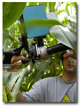
One of the focuses of remote sensing research in the Applied Climate Sciences group within the School of Natural Resources is on the influence of the vegetative community, canopy geometry, leaf optical properties, and illumination and viewing angle on reflected solar radiation. Research involves ground-based measurements and the development of relationships between the remotely sensed signal and vegetation status and functioning. Ground-based reflectance data and associated biophysical plant and soil data are essential components to understanding light interactions in vegetative canopies. Our research will lead to a significant improvement in current and future satellite algorithms and provide a foundation for better estimations of canopy status, net CO2 exchange, Net Primary Productivity (NPP), and ecosystem water and energy balance.

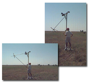
Another research focus examines the regional-scale drought monitoring capabilities of satellite-derived remote sensing data. Satellite vegetation indices potentially could provide an important tool for rangeland condition assessments in the Great Plains.