Automated Weather Data Network Wind Roses - HPRCC
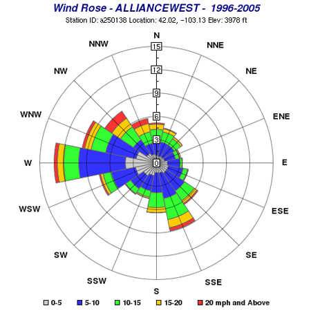
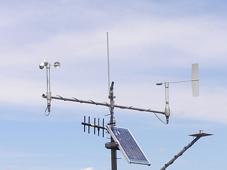
The Nebraska Wind Rose page has wind rose plots and hourly occurrence values for 16 wind directions from 1996-2005. Users can specify yearly and monthly wind rose plots for AWDN stations located throughout Nebraska. Station pictures are also included at the website

Automated Weather Data Network Maps - HPRCC
The AWDN maps show soil temperature, maximum temperature, minimum temperature, total precipitation, relative humidity, solar radiation, wind speed, and potential evapotranspiration for the past 1 or 7 days for the High Plains Region.
Nebraska Wind Energy Monitoring Program
The Nebraska Wind Energy Monitoring Program is a joint project among the Nebraska Public Power Districts, Nebraska State Government, and public interest groups. The study is coordinated by the Nebraska Wind Energy Task Force. The data are collected, quality controlled, and archived daily by the High Plains Regional Climate Center at the University of Nebraska in Lincoln, Nebraska. Data analysis and reports are produced by Global Energy Concepts (GEC) located in Bothell, Washington, a suburb of Seattle. Data include daily, hourly, and 10 minute data for the following variables: wind speed at 10m, 25m, and 40m, wind direction at 25m and 40m, temperature at 10m and 40m, and solar radiation. Standard deviations of each are available as well. Data are available from 3/21/1995-4/1/1999.