Hydrological Sciences Specialization in
Natural Resource Sciences Graduate Program
Available to both MS and PhD candidates.
SNR's Hydrological Sciences program, a specialization within the Natural Resource Sciences graduate program, aims to train the next generation of scientists studying the hydrologic cycle, its components and processes, and its complex interactions with human societies. Faculty and students in this specialization explore a broad range of hydrological topics including:
- Atmospheric moisture transport
- Surface and vadose zone hydrology
- Groundwater hydrology
- Hydrogeology
- Limnology
- Wetland management and recovery
- Water quality and biogeochemistry
- Isotope hydrology
- Contaminant transport and remediation
- Environmental geophysics and hydrogeophysics
- Remote sensing of the water cycle
- Hydrologic modeling and forecasting
- Ecohydrology
- Hydroinformatics and integrated hydrology
Faculty and graduate students in this specialization incorporate field and laboratory research techniques to answer basic and applied hydrological questions in Nebraska and across the globe.
- Expose students to inter- and transdisciplinary approaches to studying topics from across the hydrological continuum and facilitate research across the many spatial and temporal scales that hydrological processes operate.
- Formally recognize the academic achievement and experience of students who have attained advanced knowledge of hydrologic sciences.
- Provide students with opportunities to engage with the broader water science community including engineers and innovators within academic, public and private sectors
Faculty Point-of-Contact
If you are interested in the Hydrological Sciences graduate specialization, please feel free to contact the following SNR faculty member:
Admission Requirements
Please see our entrance requirements and application procedure pages for more information about our admission and application expectations for graduate degree candidates.
Graduation Requirements
- Thesis or dissertation in hydrologic sciences.
- Coursework – 20 to 24 hours total coursework from a and b belo
- Required (minimum 10 hours) [equivalent courses may be substituted if approved by student's advising committee and the SNR graduate committee];
- NRES 807 Plant-Water Relations (3)
- NRES 851 Soil Environmental Chemistry (3)
- NRES 853 Hydrology (3)
- NRES 859 Limnology (4)
- NRES 884 Water Resources Seminar (1)
- NRES 879 Hydroclimatology (3)
- NRES 875 Water Quality Strategy (3)
- NRES 898 Special Topics (1-6)
- AGRO 879 Applied Soil Physics (3)
- CIVE 856 Surface Water Hydrology (3)
- GEOL 818 Chemistry of Natural Waters (3)
- GEOL 988 Groundwater Modeling (3)
- STAT 801 Statistical Methods in Research (4)
- Select remaining courses from related elective courses (examples given below) [equivalent courses may be substituted if approved by student's advising committee and the SNR graduate committee]:
- NRES 802 Aquatic Insects (3)
- NRES 802L Aquatic Insects Lab (1)
- NRES 808 Microclimate: The Biological Environment (3)
- NRES 812 Introduction to Geographic Information Systems (4)
- NRES 818 Introduction to Remote Sensing (3)
- NRES 820 Applied Remote Sensing (4)
- NRES 821 Field Techniques in Remote Sensing (3)
- NRES 855 Soil Chemistry and Mineralogy (3)
- NRES 860 Soil Microbiology (3)
- NRES 863 Fisheries Science (3)
- NRES 864 Fisheries Biology (3)
- NRES 869 Bio-Atmospheric Instrumentation (3)
- NRES 877 Great Plains Field Pedology (4)
- NRES 889 Ichthyology (3)
- NRES 891 Seminar in Natural Resources (1)
- NRES 896 Independent Study (1-5)
- NRES 898 Special Topics (1-6)
- NRES 916 Environmental Law and Water Resource Management Seminar
- NRES 950 General Seminar (must be in a water-related topic)
- NRES 996 Research other than thesis hours (1-6)
- AECN 841 Environmental Law (3)
- AECN 857 Water Law (3)
- AECN 865 Resource and Environmental Economics (3)
- AGEN 841 Animal Waste Management (3)
- AGEN 853 Irrigation and Drainage Systems Engineering (3)
- AGEN 953 Advanced Irrigation and Drainage Systems Engineering (3)
- BSEN 855 Nonpoint Source Pollution Control Engineering (3) [CIVE855/455]
- BSEN/NRES 954 Small watershed hydrologic modeling
- BSEN 892 Special Topics
- CIVE 828 Environmental Engineering Chemistry (3)
- CIVE 830 Fundamentals of Water Quality Modeling (3)
- CIVE 852 Water Resources Development (3)
- CIVE 858 Groundwater Engineering (3)
- CIVE 958 Groundwater Mechanics (3)
- GEOL 824 Biogeochemical Cycles (3)
- GEOL 850 Surficial Processes and Landscape Evolution (3)
- GEOL 870 Field Methods in Hydrogeology (3)
- GEOL 986 Contaminant Hydrogeology (3)
- MATH 821 Differential Equations (3)
- MATH 823 Complex Analysis (3)
- MATH 824 Introduction to Partial Differential Equations (3)
- METR 811 Dynamic Meteorology I (3)
- METR 823 Physical Meteorology (4)
- METR 841 Synoptic Meteorology (4)
- MSYM 852 Irrigation Systems Management (3) [HORT852/452; WATS452]
- STAT 802 Experimental Design (4)
- STAT 880 Introduction to Mathematical Statistics (3)
- Required (minimum 10 hours) [equivalent courses may be substituted if approved by student's advising committee and the SNR graduate committee];
There are many career opportunities in a wide range of areas in the hydrological sciences. Graduates with this specialization work in industry, higher education, consulting firms, environmental groups, and federal, state and local agencies. Job possibilities include, but are not limited to:
- Hydrology
- Hydrogeology
- Water resource management
- Watershed management
- Water policy and planning
- Aquatic ecology
- Water quantity
- Water quality
- Groundwater/surface-water modelling
- Wetland restoration
- Environmental remediation
- Water analytics
Selected Dissertations & Theses
Soil Characterization with Proximal Geophysics - Sophia Becker
- Dissertation Defense
- 10/15/2025
Groundwater Modeling of the Ogallala Aquifer: Use of Machine Learning for Model Parameterization and Sustainability Assessment - Tewodros (Teddy) Tilahun
- Dissertation Defense
- 08/01/2024
Three-dimensional Aquifer Heterogeneity and Groundwater Flow Modeling for Improved Groundwater Management - Nafyad Kawo
- Thesis Defense
- 04/17/2024
Quaternary glacial aquifers are important water sources for irrigation in many agricultural regions, including eastern Nebraska, USA. Quaternary glacial aquifers are heterogeneous and comprise sediment assemblages with a wide range of hydraulic properties. Effective management and sustainable utilization of these heterogeneous glacial aquifers necessitate the development of realistic groundwater-flow models and characterization of aquifer geometry. However, hydrofacies probabilities predicted using multiple-point statistics (MPS) and machine learning (ML) techniques are rarely used for parameterizing groundwater models and identifying management zones. This study used MPS to simulate 100 three-dimensional conditional aquifer heterogeneity realizations by combining soft data, a cognitive training image, and hard data. The most probable hydrofacies model (sand and clay probability) was then calculated at a node spacing of 200×200×3 m and validated using groundwater-level hydrographs. The resulting hydrofacies probability grids revealed variations in aquifer geometry, locally disconnected aquifer systems, recharge pathways, and hydrologic barriers. A new workflow was established using the three-dimensional hydrofacies probability generated by MPS and hydrologic data to define high-resolution groundwater management zones and enhance strategies. Subsequently, ML techniques such as Random Forest, Gradient Boosting Classifier, Extreme Gradient Boosting, Multilayer Perceptron, and Stacking Classifier were used to model three-dimensional probabilistic distributions of hydrofacies at a grid size of 200 m x 200 m x 3 m. The models were compared in terms of their capability to identify thin, permeable hydrofacies, lateral continuity, and vertical contrast between hydrofacies units. ML predicted thin, permeable, and laterally continuous hydrofacies better compared to hydrofacies predicted by MPS. Multilayer Perceptron and Stacking Classifier models show sharper vertical contrasts between fine and coarse hydrofacies compared to MPS and other ML models. Finally, three groundwater models were constructed using MODFLOW 6 with unstructured grids. The first model was parameterized using hydraulic conductivity derived from pumping and geological data, while the second and third models were parameterized using hydraulic conductivity estimated from MPS and stacking machine learning hydrofacies models, respectively. K-means clustering was used to translate the predicted hydrofacies probability into hydraulic conductivity values. While the entire water budgets of all models show minimal variation, zonal water budget analyses reveal significant differences in storage change, stream-groundwater interactions, and total inflow and outflow. This study effectively demonstrates the influence of three-dimensional aquifer heterogeneity modeling approaches on the outcomes of groundwater models. Such insights can prove invaluable for groundwater managers and policymakers in assessing the implications of groundwater model parameterizations on local groundwater management.
Occurrence, inputs, and ecological significance of antibiotics and pharmaceuticals in Western Nebraska streams - Kate Glause
- Thesis Defense
- 04/16/2024
Antibiotics are a vital component of medicine, especially when treating humans and animals, however, their use can have negative consequences. Pharmaceuticals, including antibiotics, may be introduced into streams through wastewater discharge, leaching, and runoff in rural and urban settings. Even though discharging wastewater is a widespread practice, the occurrence of antibiotics in the environment may lead to changes in ecosystem processes and can influence the prevalence of antibiotic resistance. This research was established to evaluate the occurrence and type of antibiotics present in streams and determine whether urban wastewater, row cropping and manure application, or animal feeding operations are the main contributors. Three streams near Scottsbluff, Nebraska were chosen to sample based on the information gathered from other researchers and the known agricultural and urban influences. A confined animal feeding operation (CAFO) was one possible source of antibiotic presence in streams. The stream where the local wastewater treatment plant (WWTP) discharges was also chosen to study and a stream that has agricultural fields along it that may have row cropping, manure application, or livestock present throughout the year. Polar organic chemistry integrative samplers (POCIS) that allow measurement of very low concentrations of antibiotics in surface water, were placed into the streams and left for around a month to determine differences between sites influenced by wastewater, surface runoff, or seepage. Results show distinct differences in antibiotic levels between the agriculturally influenced streams and discharge from the WWTP, however, several types of antibiotics present are the same. In this review, the significance of antibiotics and water quality will be discussed, along with the fieldwork techniques, sample preparation, analysis, and conclusions. This research is important as it can lead to further exploration and understanding of the ecological impacts, antibiotic resistance, and other influences antibiotics may have when introduced to the environment.
Effect of Biomass Water Dynamics in Cosmic-Ray Neutron Sensor Observations: A Long-Term Analysis Of Maize-Soybean Rotation in Nebraska - Tanessa Morris
- Thesis Defense
- 04/10/2024
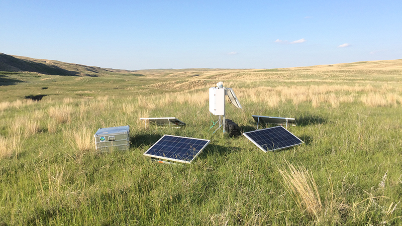
Research Projects by Hydrological Sciences Students
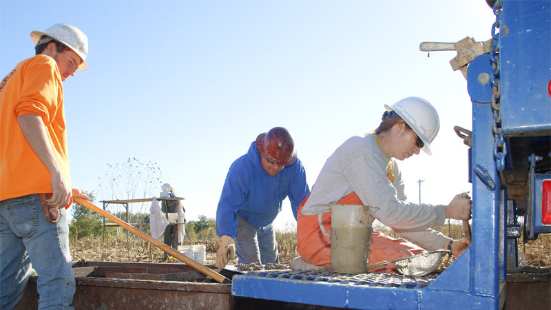
Assembled fiber-optic distributed temperature sensor (FO-DTS) on Gudmundsen Sandhills Research Laboratory. FO-DTS is a technique that uses fiber-optic cable deployed on a streambed to sense groundwater discharge into surface water. Continue the story....
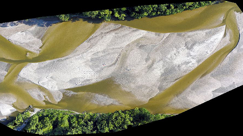
Drone imagery was used to monitor changes in stream geomorphology over time. This research project investigated processes responsible for hydraulic conductivity transience in sandy rivers. Continue the story....