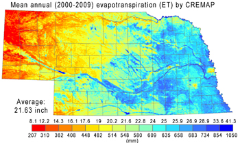
This images show the mean annual ET distribution over Nebraska, estimated by the CREMAP method.
Downloads
GRID ASCII files of the monthly CREMAP ET estimates (mm) for the January-December period each year within 2000-2009.
A short technical explanation of CREMAP and the data employed are also included in an additional document.
Contacts

This data is collected, administered, and provided by the Conservation and Survey Division.