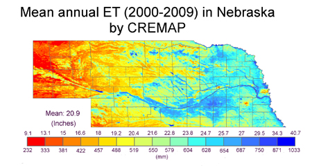
Regional ET Estimation with CREMAP
SNR hydrologist Joe Szilagyi has developed a technique he calls "Calibration-Free Evapotranspiration Mapping" -- CREMAP -- to calculate rates of evapotranspiration. It uses standard meteorological variables as well as data from MODIS, a NASA satellite that provides information on the temperature of the earth’s surface. With the help of regional-scale actual and wet-environment evapotranspiration estimates, the land surface temperature values are turned into spatially distributed evapotranspiration rates.
Website: http://csd.unl.edu/water/evapotranspiration/regionalet.aspx

Automated Weather Data Network Maps - HPRCC
The AWDN maps show soil temperature, maximum temperature, minimum temperature, total precipitation, relative humidity, solar radiation, wind speed, and potential evapotranspiration for the past 1 or 7 days for the High Plains Region.