Nebraska Real-Time Groundwater Monitoring Network
Groundwater System
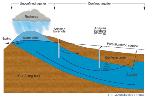
The term groundwater refers to all water which is below the surface of the ground in the saturated zone and which is in direct contact with the ground or subsoil. The saturated zone is where all the cracks in the rock and all the spaces between the grains of rock or within the soil are filled with water. The upper limit of the saturated zone may be thought of as the water table (it is shown as a dashed line on the diagram below). The zone above the water table, where pore spaces contain both air and water, is known as the unsaturated zone.
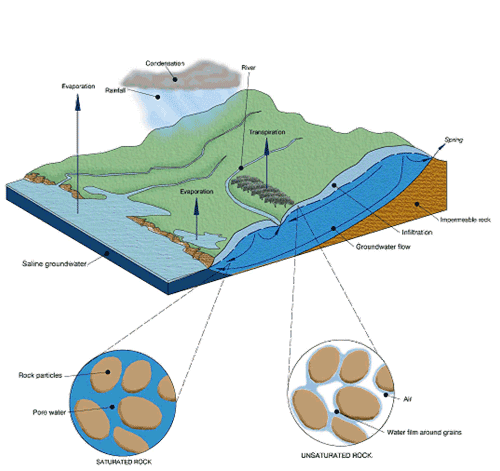
A frequent misconception of groundwater is considering it as some sort of 'underground river'. Mostly this is untrue, however in some areas, for example where there are limestone caves, underground rivers can be found.
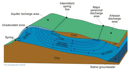
Groundwater flows through the spaces and cracks in the rock, being pulled by gravity and pushed by the force of the water above and behind it (as shown by the arrows in the diagram below). The water moves from an area where water enters the aquifer (a recharge zone) to an area where water exits the aquifer (a discharge zone). The slope of the water table, or potentiometric surface, which is termed the hydraulic gradient, will dictate t he direction of groundwater flow. Groundwater generally flows much more slowly than surface water.
The effect of groundwater flow is that a lot of impurities from the water are removed as water is filtered through the rock. Therefore in general, groundwater is generally much cleaner than surface water. This makes groundwater a very cheap source of 'raw water' for public supply.
An aquifer that is exposed at the surface is said to be unconfined aquifer. These aquifers are bounded by the water table and this is the level of water you see in a borehole. The water table has a tendency to mimic the topographic contours of the land surface above but this is not always the case.
A confined aquifer is an aquifer where a low permeability layer (e.g. clay) bounds the upper surface of the aquifer, confining the groundwater under pressure. The aquifer will therefore be saturated throughout its full thickness. Because the groundwater is under pressure, water will rise up a borehole drilled into the aquifer above the top of the aquifer.
Aquifers are susceptible to contamination from a variety of anthropogenic activities. Restoring contaminated groundwater is at best expensive and often just not possible. It is therefore far better to prevent pollution occurring than to try and deal with the consequences.
The vulnerability of an aquifer to contamination is dependent on a number of factors, namely the type and thickness of overlying deposits (both soil and drift geology), the thickness of the unsaturated zone (i.e. the depth to the water table) and the speed with which the water flows both through the unsaturated and saturated zones.