Geographic Information Systems Specialization in
Natural Resource Sciences Graduate Program
Only available to MS candidates.
Geographic Information Systems (GIS) integrate hardware, software, and data for capturing, managing, analyzing, and displaying virtually all forms of spatial data. GIS allows us to view, understand, explore, interpret, and visualize data in many ways that reveal relationships, patterns, and trends. GIS technology cuts across many disciplines and applications ranging from the medical profession to natural resource management.
Students specializing in GIS learn how to build geographic information systems and how to apply these systems to topics including:
- Land-suitability modeling
- Risk assessment
- Decision support
- Conservation planning
- Landscape ecology
The GIS program area is also closely linked and integrated with the specialization in remote sensing.
Faculty Point-of-Contact
If you are interested in the Geographic Information Systems graduate specialization, please feel free to contact the following SNR faculty member:
Required Courses:
- NRES 427/827 - Introduction to the Global Positioning System (GPS) (2 cr)
- GEOG 422/822 - Advanced Techniques in Geographic Information Systems (4 cr)
- GEOG 432/832 - GIS Programming (3 cr)
Elective Courses:
Minimum of one course listed below and approved by the student’s advisory committee.
- NRES 412/812 - Introduction to Geographic Information Systems (4 cr)
- GEOG 427/825 - Scientific Visualization in Cartography (4 cr)
- NRES 922 - Seminar in Geographic Information Systems (3 cr)
Additional supportive courses in Geographic Information Systems as well as remote sensing, image processing, and spatial statistics are also available through SNR and the departments of Civil Engineering, Community and Regional Planning, Computer Science and Engineering, and Statistics.
Please see our admission requirements and application procedure pages for more information about our admission and application expectations for graduate degree candidates.
Demand for persons having training in GIS has been increasing annually. There are numerous employment opportunities throughout the private, governmental, and academic sectors and across the globe. Natural resource managers, biologists, botanists, ecologists, environmental regulators, hydrologists, planners, foresters, and farmers rely on the analytical power of GIS to help make critical decisions to manage the earth's resources.

Selected Theses
Analysis of Drought-Flood Abrupt Alternation Events and Their Impacts in Kenya - Betty Makena
- Thesis Defense
- 07/01/2024
Various Research Projects
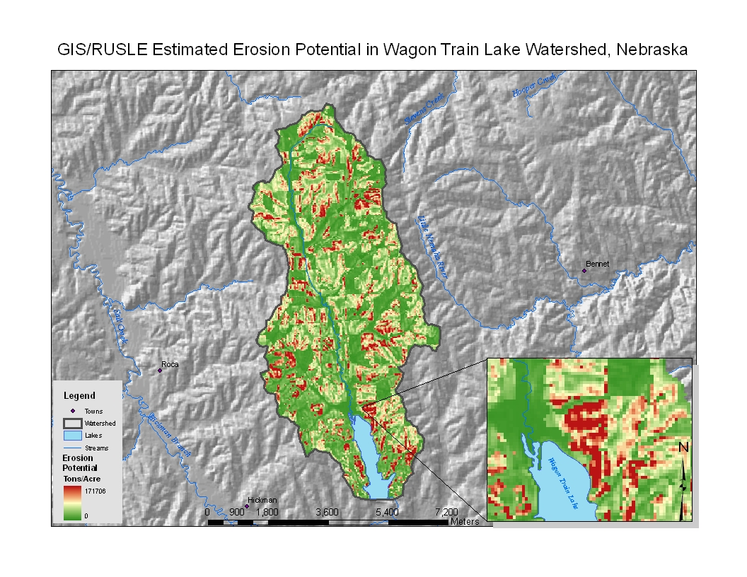
Research demonstrates a new approach to using GIS for estimating runoff in small watersheds. Part of Amy Zoller's MS thesis.
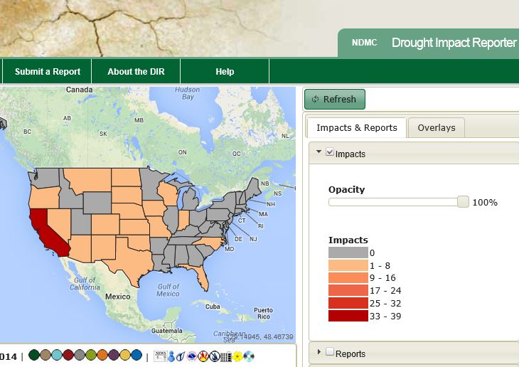
WebGIS technology benefits the drought impact mapping across the nation, This project was done in a collaboration of NDMC and CALMIT